Day 7

Day 7 had it's ups and downs.
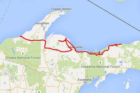
The plan was to ride to Big Bay and try and work my way over to Skanee on the trails south of the Huron Mountain Club. Michigan had begun construction of M35 up there way-back-when, but Henry Ford and his rich friends put a stop to it. They bought up a bunch of land and formed the Huron Mountain Club, private land patrolled by armed guards. I wanted to explore those old roads and see if I could find my way across. I didn't make it.
But first, breakfast in Grand Marais

Breakfast at Breakwall Cafe in Grand Marais
Then a run to Pictured rocks to run down H-58, a darn fine road. I stopped at a couple of the lookouts. I've been here before so I didn't stop for long.

Pictured Rocks National Seashore
It kinda bummed me out to see the vandals debate science, but the people behind me laughed at it and that helped me smile. I guess when your deepest beliefs involve Jesus riding a dinosaur, this kind of disinformation must be upsetting.


I had a hotel reservation for the next two nights. It was the 4th of July and I didn't want to worry about campgrounds being full, so I reserved a place on the lake I like for a couple nights. It was a bit of a haul to get there, and I wanted to take those back roads out of Big Bay, so I needed to make miles.
Around lunchtime I considered stopping at the Tioga Tavern, but ended up deciding against. I wandered around Marquette a bit looking for a coffee shop for lunch and ended up at Donckers which I highly recommend. It's up above a candy store. Kinda a bustling place, a bit crowded, but awesome food and service. I shared a table with a family, but we kinda politely ignored each other. They had enough dynamics between them all to navigate, they had no capacity to add a stranger to the mix.

Tioga Tavern

Donckers in Marquette
As I got up to Big Bay I found the Thomas Rock overlook. There were some ATV guys who assured me it was worth the walk, and we talked about the roads between Big Bay and Skanee. They were helpful, but they were explorers/wanderers too, not quite sure where they were most of the time.


Thomas Rock Overlook near Big Bay
Then I ran into Big Bay for a last tank of gas. Also, I have some friends who live there, unfortunately they were out of town. They had offered me their house anyways, and at one point I had planned on at least camping on their property. But, I spent extra time up in Canada so I was behind schedule, but I at least wanted to find the house.
So I wandered around a bit looking for them, enjoying the last of my swagger before I dumped my bike and got all kerfluffled.
I had actually almost dropped my bike a couple times by now. I had picked up this habit of being too aggressive on the front brake while stopping and turning at the same time. With the bike a bit heavy there were a few times I had to fight to keep it standing in those situations. This time I lost the fight. At the last minute I decided to take a side road and braked and turned simultaneously. As the bike fell I had my foot on the ground trying to keep it up. It happened fast, but to the degree I got to think as it happened I thought I didn't want to wreck my lower back fighting it. So down she went. I was unhurt for sure. The bike was fine, just a bar end mirror broke off and got scuffed.

Minor accident
But it got my adrenaline going a bit. I took some quick pics, cause that's what I seem to do, and folks stopped to make sure I was OK. One guy helped me pick it up. I guess I wasn't embarrassed, just a bit resigned.
Also, I have a lot of miles on my bike. I ride a lot and not much of it on straight roads. I'm fairly good on the bike, good in the curves and I'm not afraid to get in some tough spots now and then. What I'm saying is, without being cocky, is that I'm a bit cocky. And this bike on it's side suggested maybe I wasn't so great a rider. In short, it was a bit humbling.
So, one guy who stopped was alpha-male cruiser guy in his big pickup who knew everything about motorcycles. I got some free advice from him and all that. I got some directions from him on the road to Skanee.
After not too long everyone dispersed and I headed out of town to find the road. I gave up on exploring Big Bay, the day was getting late and I wanted to get away from the scene-of-the-crime. A bit north of town I stopped to take a deep breath, get the last of the adrenaline out of my system, and consult my map.
And alpha-male cruiser guy pulls behind me, deciding I wasn't done needing help. Arg. And it ends up I'm following him to the head of the dirt road leading to Skanee. He was being helpful, he was actually a real nice guy, but I didn't want help and I screwed up by just not telling him that. I was a freaking motorcycle adventurist, I didn't want to be following anyone.
But despite the grinding of teeth under my helmet, it wasn't actually that big a deal. He got me to the gravel road and we said bye.
I rode by the Eagle Mine towards Ford Rd, and the road was OK. Then it got a bit sandy, then it turned into beach sand. Fine, white, impossible beach sand.

Ford Rd near Big Bay
And I didn't handle it well.

Ford Rd near Big Bay
I use a lot of rear brake when riding. I think because going into a curve I find is upsets the bike less then the front brake. And I am fortunate to live near roads such that I am going into a curve a lot. But, what I read is that the motorcycle gods say I should use more front brake. And I do lock of the rear sometimes on a fast stop on pavement because I use so much rear. So, I've been training myself to use more front.
But in the dirt that's not as good an idea. And I'm on pavement and then on gravel and over thinking my braking. I was in an uncomfortable transition period as I worked on my braking. And I had recently lost a tad of confidence.
So, on this soft sand I was standing on my pegs and trying to use my rear brake, which is tough while standing. But when my front dug into the sand instead of giving more power I reflexively grabbed the front brake, plopped down on my seat and let my feet come off the pegs. Those divots next to the tire track above are from my boots.
It was a mess. I went though this routine about three times. Sand is hard to ride in, the Bonnie is fairly heavy, and it's a pretty bike and I don't want to drop it. To learn how to do this I needed a lighter mule like a dr650 that I wasn't afraid to drop, and more swagger.
I didn't know how much more of this stuff I had ahead, so I quit. I turned around with my tail between my legs. Or I simply made a wise choice and adjusted to the conditions. Probably the latter, whatever.
I really wanted to find my way though those roads, so I was disappointed. But I had a nice ride down CR510, which is a gravel road that parallels the hardtop I took up to Big Bay. Much more my speed.

CR 510
On a high bridge over the Dead River I pulled a u-turn to take in the view. There was a cool old bridge down below. The one I was on replaced the one below. There were some informational signs. If you're into such things you can click on the pictures below and you'll get to a larger version of the image that you can read the text on.

Old CR 510 Bridge

New CR 510 Bridge


1921 CR 510 Bridge
The County Road 510 steel truss bridge over the Dead River owes its existence to the passage of a few key Acts by the Michigan Legislature in the early 1900's. The first of these acts was the Trunk Line Act of 1913, which provided for the laying out of a system of trunk lines in the state of Michigan. With this act, the state would pay a "reward" to the local units of government to build parts of the state road system. This system remained in place until it was acknowledged that building a road network of this type was of state-wide interest and the Aldrich Act of 1919 was passed. Under the Aldrich Act, the State of Michigan assumed full responsibility for maintaining and completing the system, with local units of government contributing aid back to the State of Michigan. Completing this work meant a much larger state organization was needed (in addition to help from county organizations). Agreements were immediately made with county organizations to take charge of construction contracts, and all work was to be done under the direction of the county's District Engineer.
In December of 1919, an agreement (under the provisions of the Aldrich Act) was made between the Board of County Road Commissioners of the County of Marquette and the State Highway Department to build portions of state trunk line M-35 (also known as the Baraga Trunk Road). This road was designed to run northwesterly from Negaunee through the Huron Mountains of Marquette and Baraga Counties, then southwesterly along the Keweenaw Bay shoreline to L'Anse. In building the portion of this highway that ran through Negaunee Township, the State Highway Department was faced with the task of bridging the Dead River
In the fall of 1919 the state purchased a 265 ft. span through curved chord Pennsylvania Truss bridge which was being removed from its original site because it was one of two toll bridges crossing the Allegheny River within five hundred feet of each other and this bridge was considered unnecessary. The structure was shipped to Marquette County and was erected on site in 1921 under the supervision of Marquette County Road Commission Superintendent Kenneth l. Sawyer. Contractors involved with the project were R.L. Ericson, Gust Anderson, the C.M. Neeld Construction Company, and the Illinois Bridge Company. The total cost of the project was $80,710, with the State Highway Department paying for 77.5% and the Marquette County Road Commission covering the remaining 22.5%.
The bridge remained a part of the M-35 corridor until 1939 when the State Highway Department officially cancelled the route due to complications with crossing the Huron Mountains. Once the M-35 project was cancelled, the bridge and portions of the road that were completed were then turned over to the local entities. It was at this time that the route became known as County Road 510 The bridge served the County of Marquette well for many years, being used as a connector allowing logging activities, residential development, and other economic activity such as tourism north of the Dead River. When a weight limit of 51 tons was placed on the bridge in the mid-1990's, many commercial vehicles were not able to use the bridge; a lengthy and costly detour route had to be used.
In May of 2003, the bridge survived the Silver Lake Flood which was caused by a breach in the Sliver Lake Dam. The water reached a level of two tenths of a foot below the bottom girder of the bridge and amazingly the structure escaped without harm. In the same year, the weight limit was reduced further to 40 tons making the need for a new bridge of even greater importance.
After many years of planning and design, plans were finalized for a new bridge which would be located approximately 1,300 feet upstream from the steel bridge. The building of the new bridge came just in time as the weight limit on the steel bridge was lowered to 25 tons in May of 2009. This bridge weight limit shut off this route to almost all truckers in the area, including snowplows for the Marquette County Road Commission; the bridge itself had to be plowed with a pickup truck.
The bridge is of historical significance as there is only one other similar structure in the state. For that reason, the steel bridge remains in its original location. The steel bridge can be viewed by looking to the east of the new crossing or by driving down to the end of the old County Road 510 approaches which are now known as County Road JWW and County Road JHH.
1921 BRIDGE FACTS
- 271 FEET LONG (ABUTMENT TO ABUTMENT)
- 20.01 FEET WIDE
- 10 FEET ABOVE THE WATER
- 1 SPAN
- TOTAL COST: $80,710
- OPEN TO TRAFFIC: 1921
- CLOSED TO TRAFFIC: 2010
2010 CR 510 Bridge
In March of 1999, the Marquette County Road Commission (MCRC) received word from the State of Michigan that critical bridge funding for replacing the CR 510 Bridge over the Dead River had been approved. It was at this time that the planning process was started for the bridge replacement; this process was not without its difficulties. After having many delays due to things such as right-of-way acquisition, exploring different road alignments, having to concentrate efforts to emergency construction due to the Silver Lake Flood, obtaining the Michigan Department of Environmental Quality (MDEQ) permit, and the inability to obtain soil borings for the structure itself, the MCRC decided to let the project out to bid in two phases.
The first phase of the project was let out for bids on September 7, 2007. Oberstar, Inc. of Marquette, Ml, was the low bidder at $1,623,161.29. Beginning in November Of 2007, sub-contractor Zenith Tech started to install a three-sided culvert and Oberstar, Inc. began earth excavation to establish a road grade for the bridge approaches. The three-sided culvert allowed for a "natural" streambed at the crossing of a tributary to the Dead River. This 6 ft. x 5 ft. x 149 ft. three-sided culvert was required by the MDEQ and ran a total installation cost of $234,698. Due to the terrain, many earth haulers were present on the project for months to establish the final grade on the bridge approaches. The largest earth cut made on the project was 54 feet (north side of the bridge) and a total of 230,402 cubic yards of earth were removed from the site at a cost of $711,943. In November of 2008, the earth excavation and grade work were completed and Payne and Dolan placed the first course of asphalt on the approaches. It was at this time that the first phase of the 510 bridge project was complete and the final project costs totaled $1,738,276.78.
Total project costs of phase one of the project were slightly higher than anticipated due to the fact that a "switch back" road had to be built on the north side of the river. This road was needed to provide access for a soil boring rig to obtain soil information near the river and for the bridge construction phase of the project. The bridge design firm, Wilcox Professional Services, needed critical soil information to finalize the plans so that the actual building of the bridge could begin.
Once plans for the bridge itself were completed, the second phase of the project was let out for bids on August 6, 2009. Lunda Construction Company of Black River Falls, WI, was the low bidder coming in at $4,484,024.83. Construction began in September of 2009 with work on the north and south abutments and the two center piers. By November of 2009, the footings for the piers, the pier columns, pier caps, and the abutments were assembled and poured. The project remained idle over the winter months, with the only activity being the delivery of the steel girders and the assembly of the south sections of girders in March of 2010. Due to the inability to deliver a second crane to the project because of spring weight restrictions, the assembly of the girders could not resume until May of 2010. It took approximately two weeks for Ace Steel Erection, Inc. of Shelbyville, MI, to assemble the girders and make the bridge ready for decking. By June 28, 2010, the reinforcement steel was in place and the deck was ready for concrete to be poured. The deck was poured in several phases and was wet cured for seven days. After the deck was complete, the sleeper slabs were poured and finally the approach slabs were poured, completing the concrete work on the bridge. The total amount of concrete used for the bridge was 1,784 cubic yards, or in other words, 200 loads of concrete were delivered. After the bridge painting was complete and the second layer of asphalt was placed on the approaches, the bridge opened to traffic on September 17, 2010. Work in and around the old County Road 510 bridge approaches continued over the next several months. The work involved building cul-de-sacs on both approaches near the old steel truss bridge to officially close it to vehicular traffic. The second phase of the project was complete by November of 2010 with a final dollar amount of $4,920,389.04.
2010 BRIDGE FACTS
- 532 FEET LONG
- 36.52 FEET WIDE
- 100 FEET ABOVE THE WATER
- 3 SPANS
- TOTAL CONSTRUCTION COST: $6,658,665.82
- OPEN TO TRAFFIC: SEPTEMBER 17, 2010
So, that may not have been so interesting ...
I rode down to the old bridge, and it was closed. But I rode across it anyways because ... motorcycle adventurist, remember?

Old CR 510 Bridge
I made a pretty uneventful run to Ontanogan (I barely had any UFO problems at all) to stay at one of my favorite cheap motels, in time to fetch some beers and snacks and enjoy the sunset.

Beware, UFOs and cows.

Scott's Superior Inn, Ontonagon

Sunset at Ontonagon

Lakeshore at Scott's Superior Inn